
“Science for the people”. This was expressed by Department of Science and Technology (DOST) Secretary Fortunato de la Peña as DOST’s new banner call during the Philippine National LiDAR Conference 2017 on January 18-19, 2017 in Cebu City.
“It is our commitment to ensure that our efforts to further advance science will be down to tangible, concrete benefits to Filipino men and women especially in the countryside—in other words, to have science work for the Filipino,” he added.
The conference aimed to present project progress, utilization and application of LiDAR technology, and the sustainability of Phil-LiDAR facilities and personnel. It was attended by 400 participants from the academe, government agencies and private sectors nationwide with the theme, “On the cutting edge: Geospatial technology at the forefront of disaster risk reduction and natural resource management in the Philippines.”
Phil-LiDAR or Light Detection and Ranging Technology is designed to produce more detailed, up-to-date, and high resolution multi-hazard maps to help the communities plan disaster mitigation efforts and avoid catastrophic damages and casualties. It had produced 2,319 flood hazard maps all over the country which were distributed to its respective local government units.
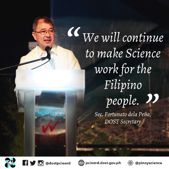
DOST Secretary Fortunato dela Peña delivering his message during the PNLC 2017.
Special Sessions on DRRM, Environment, and Agriculture and Infrastructure
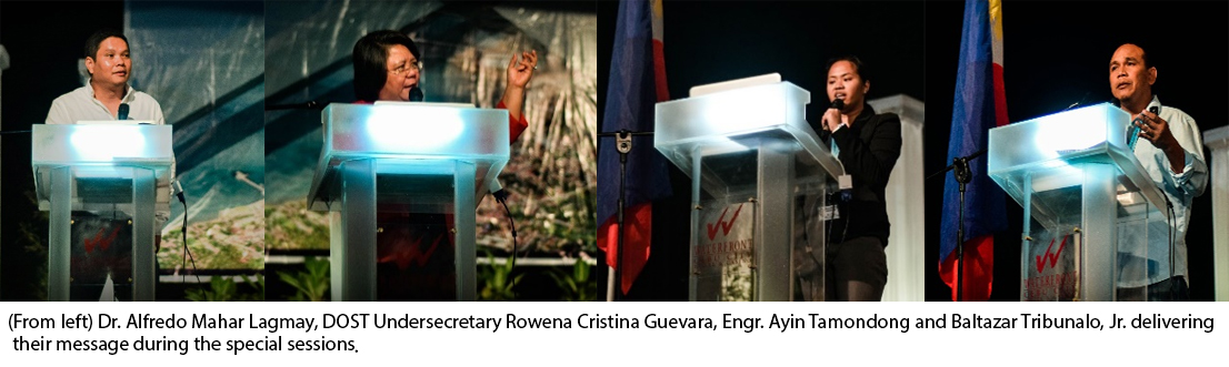
There were special sessions held on disaster risk reduction and management, environment, and agriculture and infrastructure. Dr. Alfredo Mahar Lagmay, Executive Director for the National Operational Assessment of Hazards (Project NOAH) introduced the project and its accomplishments in disaster mitigation especially the development of probabilistic multi-scenario-based multi-hazard maps that can be used to simulate possible disaster scenarios that have not happened before. Baltazar Tribunalo Jr., Head of Cebu Disaster Risk Reduction and Management Office, said that they will integrate these maps to their provincial and city/municipal planning process and initiate a bottom-up approach instead of the usual top-to-bottom DRRM paradigm.
Project leaders from UP Diliman, Forester Nerissa Gatdula and Engr. Ayin Tamondong discussed the applications of LiDAR data for agriculture and aquatic resources. Some of the applications mentioned for agriculture are Precision Farming which helps maximize food production, and Soil Survey Mapping that identifies soil types which in turn reduces the work needed. While Automated Rapid Reef Assessment (ARRAS) for monitoring of corals using underwater video and stitching software, and the development of climate-ocean typology for national vulnerability assessment are few of the uses of LiDAR for aquatic resources.
Aside from the public sector, private sector representatives were also present in the discussions. Rene Meily, President for the Philippine Disaster Resilience Foundation (PDRF), presented the efforts done by the private companies for disaster risk reduction and management, saying that PDRF’s goal is ‘from recovery to resiliency.’ Atty. Gloria Estenzo-Ramos of OCEANA Philippines, the largest non-government organization on fisheries, shared their organization’s mission and vision hoping that there may be a convergence between OCEANA and the LiDAR team to protect and conserve the Philippine coastal areas.
DAY 2—A total of 87 technical papers were presented during the second day of the conference. These presentations were divided into parallel sessions according to the following: disaster risk reduction, agriculture and infrastructure, and environment and climate change.
In-between the sessions, Cong. Erico Aristotle Aumentado, Chairman of Science and Technology Committee in the 17th Congress, recognized the accomplishments of Phil-LiDAR projects in mitigation strategies for resilience to climate change and disasters. He further extended his support to the team’s future agenda that are potentially useful and are game-changers to hazard management and climate change.
Phil-LiDAR Program nears completion
“The underlying theme is sustainability—sustainability by expanding partnerships and collaboration, by continuing research and related activities on geospatial science and technology, development and utilization, and by mainstreaming methodologies and products,” said Program Leader for Phil-LiDAR 2 Dr. Ariel Blanco in his remarks.
With the project nearing its completion, DOST Undersecretary Rowena Cristina L. Guevara encouraged the various institutions to come up with plans to sustain Phil-LiDAR facilities and trained personnel. She offered DOST services that could provide funding for their projects with priority to those that will fall in the four new programs of DOST’s R&D agenda, namely: 1) Collaborative R&D for industry with academe (CRADLE); 2) Business innovation for industry (BIST); 3) Niche centers for R&D in the region (NICER); and 4) R&D Lead.
Dr. Enrico Palingit, Program Leader for Phil-LiDAR 1, gave four possibilities of the program to stimulate ideas: 1) Extending project duration for some of the projects; 2) Expanding coverage; 3) Enhancing the products developed from the program; and 4) Engaging stakeholders in the process—strengthening of the network of personnel working in the program.
Simultaneous business meetings for Phil-LiDAR 1 and 2 were held after the two-day conference which served as an avenue for the teams to discuss the accomplishments and sustainability plans of each university/college. Sustainability plans included strengthening of existing GIS Resource Centers and building Centers for Geoinformatics, Climate Change, Spatial Analysis Study, Advance Geo-Spatial Technology Application, Geomatics, Environmental Conservation and Research that will serve as GIS hub and training center, Big Data Research and Analytics Laboratory, and Regional Monitoring and Training Center for Hazards and Disaster Assessment and Geospatial, Photogrammetry and Remote-Sensing Studies.
LiDAR Portal for Archiving and Distribution (LiPAD)
Phil-LiDAR data such as Digital Elevation Models, Digital Terrain Models, Orthophotos, Classified LAZ, Flood Hazard Maps and Resource Maps are made accessible and available for download through LiPAD. To access the portal, go to: http://lipad.dream.upd.edu.ph.
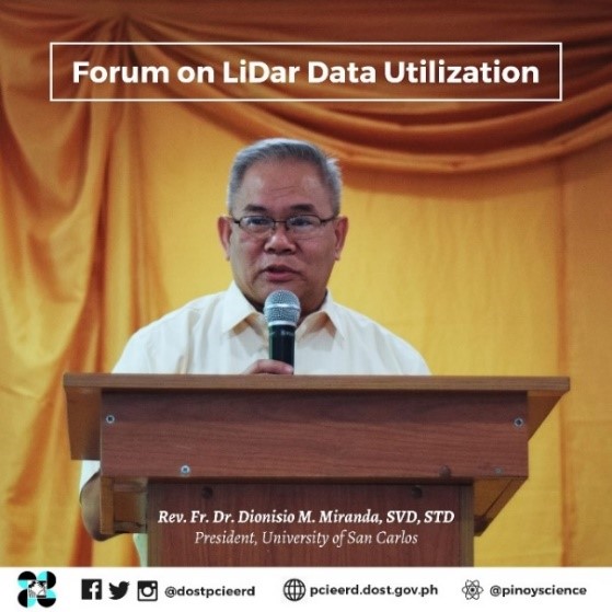
Forum on LiDAR Data Utilization
The following cities and municipalities received the Hydrologic and Forest Maps: Bogo City, Santa Fe, San Francisco, Daanbantayan, Tabogon, Bantayan, Catmon, Tuburan, Oslob, Borbon, Tudela, Dalaguete, Toledo City, Lapu-Lapu City, Carcar City, Medellin, Sogod, Tabuelan, Barili, and Ronda.
Phil-LiDAR is a project led by the UP Diliman Training Center for Applied Geodesy and Photogrammetry (UPD TCAGP) together with partner universities, Ateneo de Naga University (ADNU), Central Luzon State University (CLSU), University of the Philippines Los Banos (UPLB), Mapua Institute of Technology (MIT), Isabela State University (ISU), Mariano Marcos State University (MMSU), UP Baguio (UPB), Visayas State University (VSU), UP Cebu, University of San Carlos (USC), Ateneo de Zamboanga University (ADZU), UP Mindanao, Caraga State University, Mindanao State University-Iligan Institute of Technology (MSU-IIT), Central Mindanao University (CMU) with funding from DOST and managed by the DOST-Philippine Council for Industry, Energy and Emerging Technology Research and Development (PCIEERD).

