Once is an honor, but twice is a testament of true Filipino eminence.
The Department of Science and Technology's (DOST) and the University of the Philippine's 3D Mapping project called Disaster Risk Assessment, Exposure and Mitigation-Light Ranging and Detection Technology (DREAM-LiDAR), has once again been recognized in the world, specifically in Asia, as it was chosen as Asia Geospatial Excellence Awardee by the Asia Pacific Geospatial Media and Communications.
DREAM program leader Dr. Enrico C. Paringit, a professor from the University of the Philippines Diliman, together with DOST Assistant Secretary Raymund E. Liboro and Dr. Fidel R. Nemenzo, UP Vice Chancellor for Research and Development, received the Asia Geospatial Excellence Award presented during the Asia Geospatial Forum 2014 on November 25-27 at Hotel Mulia, Jakarta, Indonesia.
The Asia Geospatial Forum (Formerly known as Map Asia) has established itself as the most premier and sought after conference and exhibition on geospatial technology and applications in Asia Pacific. It is now widely recognized as one of the most important geospatial industry event in Asia and welcomes about 800 high profile delegates from policy makers, technology providers, end-user segments and academic communities across the region every year. With a rich programme agenda comprising plenary sessions, parallel events and technology tracks, the conference offers key trends and discussions on the different application in geospatial key disciplines.
Through Geospatial Media and Communications, the nominees for Asia Geospatial Excellence Award are selected through a rigorous process and eventually judged by international panel of experts to honor geospatial technology developers, professionals, end users and policy makers for their exemplary technology innovations and applications development in various fields in the Asia Pacific.
Geospatial Media and Communications, as the world's famous and credible media in geo-related industries and technologies, aims to build awareness about the relevance, significance, innovations in and applications of geospatial technologies. Their ultimate goal is to have as many government agencies and private sector companies to utilize the power of geospatial information across the world as possible.
The DREAM-LiDAR, the biggest single project that a research unit in the entire University of the Philippines system has ever undertaken, also recently bagged the Geospatial World Excellence in Policy Implementation for 2014 by the same award-giving body. Said award was received by the DOST Sec. Mario G. Montejo and Dr. Enrico Paringit last May 8, 2014 at Geneva, Switzerland. Other notable recipients of the highly coveted award were the United States National Aeronautics and Space Administration's (NASA) Earth Science Division-Applied Sciences Program; and the Bilateral Cooperation of the International Joint Commission in Canada and USA for 2013 and 2012 respectively.
A component of the Nationwide Operational Assessment for Hazards (Project NOAH), the DREAM-LiDAR aims to address and help mitigate the effects of flooding disasters in the country by collecting precise geospatial data with LiDAR to produce detailed topographic information that will enable the creation of more accurate flood inundations maps.
The project's main deliverable is an accurate national terrain elevation map to be used for creating flood plain inundation maps and for performing on-demand floor simulations. The digital terrain maps will cover all relevant river basins with one-meter horizontal resolution and 20-centimeter vertical accuracy. The project requires elaborate preparation and training of local staff to carry out various technically challenging tasks such as hardware installation, flight planning, LiDAR quality checking, data pre- and post-processing, and flood modeling, among others.
Creating technical expertise as it is implemented in an educational institution, DREAM-LiDAR is constantly training and self-educating the local staff. Upon completion of the project, it is expected to have created a pool of highly-skilled LiDAR and Flood Mapping experts. These experts can apply their technical knowledge and skills in government agencies and commercial enterprises and get further value from the collected elevation data or innovate for novel 3D applications.
Aside from producing both product and expertise needed to exploit data at a much lower overall cost while also creating new high-tech jobs across the Philippines, DREAM LiDAR also hopes to inspire other nations in charting their own national mapping programs. The DREAM LiDAR project is housed at the National Engineering Center of the University of the Philippines Diliman in Quezon City. The project is monitored by DOST's Philippine Council for Industry, Energy and Emerging Technology Research and Development (DOST-PCIEERD).
Receiving two prestigious awards this year only proves that innovations in the Philippines are now at par with those of first world countries who have the financial and technological capabilities to produce award-winning results. (Arlyn Joy P. Amata)
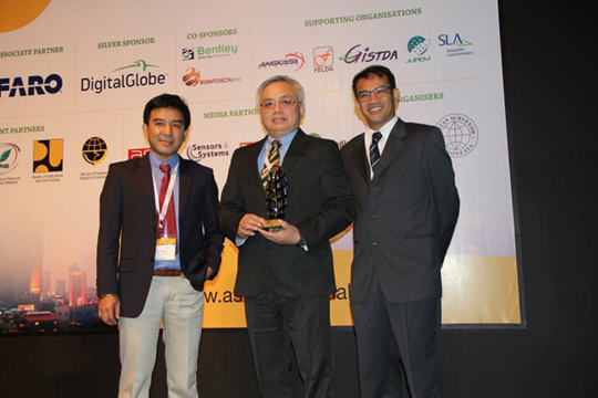
(From left): Dr. Fidel R. Nemenzo, UP Vice Chancellor for Research and Development, DOST Assistant Secretary Raymund E. Liboro, and Dr. Enrico Paringit, Associate Professor at UP Diliman and DREAM Project Leader, received the Asia Geospatial Excellence Award last November 25-27 in Indonesia.)

